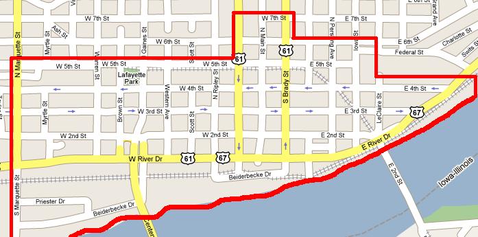
 I made this in about a minute, so I'm sure that it doesn't entirely reflect even my opinion. My point, however, is that I think we all have different definitions of what is and isn't part of downtown. Is Central High School downtown? Is Kraft (Oscar Mayer) or even Ralston? To the east, is the former Wonder Bakery downtown? The Cityview has been called a downtown apartment building, but to me anything at the top of the hill is above downtown.
When the QCTimes pushed to kick River Gulf and Builders off their leased riverfront land to keep their cars from getting dusty, they referred to those businesses as downtown. At the time I thought to myself that those businesses were on the fringe of downtown if anything. When I went to draw the map I started with the railroad embankment as the northern border, and then realized I was mapping myself out of downtown. I consider the warehouse district to be downtown, but I could see how others might not.
What do you people consider the boundaries of downtown Davenport to be?
4 comments:
I WOULD SAY THAT THE DOWNTOWN BOUNDARIES ARE BEST DESCRIBED AS GAINES STREET ON THE WEST AND 5TH STREET ON THE NORTH, WITH THE RIVER BEING THE SOUTHERN BOUNDARY. OSCAR MAYER, RALSTON PURINA AND THAT STRETCH OF RIVER DRIVE EAST OF OUR ONE WAYS ARE DEFINITELY NOT DOWNTOWN.
ACTUALLY I STOPPED CALLING THIS AREA DOWNTOWN ABOUT THIRTY YEARS AGO BECAUSE THERE IS NOTHING GOING ON DOWN THERE. THE ONLY REASON I END UP DOWNTOWN IS TO STOP AND HAVE SOME COLD ONES AT PADDY'S.
Ok downtown Davenport is defined. So how is the rest of Davenport segmented?
How would you say that the rest of Davenport is divided up? Many people would say East/West, but even there, where's the dividing line? Main street may be the boundary for addresses, but I hardly think people believe everything west of there is "West Davenport." SoLo, NoLo, NoKi? That ignores the fact that Crestwood and Goose Creek are north of Kimberly, while the Heights are south of Locust.
I'll respectfully disagree with the boundaries defined on the west by Gaines. Your map more accurately reflects the commercial and service industry end of downtown along 4th, 3rd and 2nd to Marquette. Great service businesses like Burkes, Peterson Plumbing, Midwest Publishing, Auto Ron's, River Cities Sound and Lights, Abraham Machine, Tighton Tool Co., Servicemaster-to name a few! Hundreds of people work and come to do business there every day. Despite a long history of being ignored by "downtown planning"-this area is an important economic base. With the exception of one basic area of trouble-Sugar's and the stupid liquor store across from it-most parts of the neighborhood are well maintained and have in fact, improved in the past three years. Reclaiming the abandoned historic structures on 3rd Street combined with Tommy's renovation and expansion and Peterson Plumbing's major investment in the old Hockenberg's building demonstrate the real commitment of established family owned businesses. The City's recent addition of new alley and street lights has also led to a new feeling of renewal. Now if we could only get the City to get serious about the Myrtle Street problems we would have a a real gateway to downtown.
Post a Comment